
Climate change is already transforming the globe; temperatures and sea levels are rising, oceans are warming, floods as well as droughts are rampant, habitats are at risk of collapse, and more. These developments have harmed countless people on a worldwide scale. So, when you pair a rapidly changing climate with a global climate phenomenon, things are only bound to get worse for millions. Well, after only a two year gap, another El Niño has formed. But what exactly is El Niño, and why is this one so important?
The El Niño-Southern Oscillation (ENSO) alters temperatures and precipitation globally and is widely considered to be one of the most important and influential climate patterns. ENSO has occurred for millions of years and records of it date back centuries. It has three phases: El Niño, La Niña and a transitional phase named ENSO-Neutral. El Niño got its name after fishermen off the west coast of South America in the 17th century noticed that warmer temperatures would arrive around late December. They dubbed this occurrence “El Niño de Navidad” although it eventually got trimmed to just “El Niño” or “the little boy”. Scientists thought “the little girl” would be a fitting name for El Niño’s sister. La Niña is the “cooling” phase and is identified when easterly trade winds intensifying, pushing warm ocean surface water towards Asia where deep colder water off the coast of South America upwells (rises) to replace it. This cools parts of the Pacific Ocean and shifts atmospheric circulation (notably jet streams) and leads to weather changes around the world. El Niño, is the “warming” opposite where easterly trade winds slow or sometimes reverse which pushes warm surface water towards the Americas, also disrupting atmospheric circulation whilst warming the Pacific. Both El Niño and La Niña irregularly form every two to seven years and last for at least nine to twelve months, yet several instances have been recorded of them lasting even longer; their intensities vary and are designated from weak to very strong.
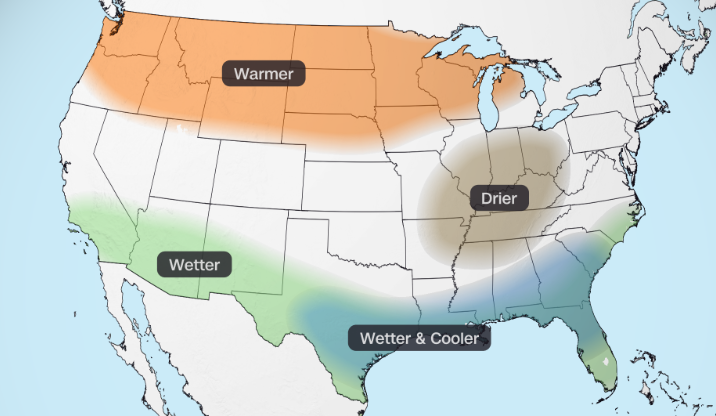
A map detailing El Niño’s impact on the United States.
El Niño specifically is marked by several regional weather developments on a global scale. Eastern Africa and parts of South America face immense rain and floods. In Australia, southern Africa, and southeast Asia, precipitation decreases while drought and heat waves are severe, which puts these places at risk of agricultural decline and wildfires. Marine life is directly affected since the weakened easterly trade winds brought on by El Niño greatly diminish cold-water upwelling in the Pacific. Warm water is much less nutrient rich than cold water, and so phytoplankton, which are microscopic plant-like organisms, starve and die out. In turn, fish and marine bird populations who rely on phytoplankton decrease severely. As for the United States, El Niño makes it difficult for hurricanes in the Atlantic to form and brings wetter conditions to the South as well as warmer conditions in the Northeast. The Pacific Northwest is both warmer and drier while the Midwest is expecting a warm winter. Overall, El Niño also raises global temperatures. But, isn’t El Niño a normal occurrence? Why is this one so special?
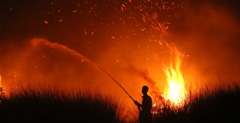
An Indonesian villager fighting a wildfire, August 2026.
Well fortunately, El Niño is predictable. This current one was declared in June. However, many experts are ringing the alarm bells. Several high temperature anomalies as high as 7°F in the Pacific Ocean have strengthened the formation of this new El Niño. Historically, El Niño builds up in fall and winter, but this one was already having a great impact on the world during the summer. Very quickly after its formation, the National Oceanic and Atmospheric Administration classified this El Niño as “very strong” and warned that this could be one of the strongest, if not the strongest, on record. For example, Panama declared a national state of emergency in August due to concerns of drought, flooding, and operating the Panama Canal. In Nigeria, El Niño has likely amplified heat waves, which puts thousands at risk of heat related deaths. Indonesia meanwhile has faced its worst wildfires in over a decade. The U.S. especially has felt the effects of the changing weather patterns. In part due to El Niño, July was the hottest month on record in the country’s history with an average temperature of 76.9°F. In September, California declared a state of emergency amid local sea levels rising by nearly 12 inches and a high risk of heavy precipitation brought on by El Niño. Recent floods in the Four Corners states have been directly linked to El Niño. In fact, remember the nor’easter storm that cancelled Homecoming? El Niño’s shifting of jet streams provides a direct link to the formation of nor’easters in the North Atlantic. On top of all these developments, it is important to note that the Trump Administration’s recent cuts to the federal government have put the country at a greater risk of not being able to properly research and respond to this El Niño.
This Super El Niño is expected to peak in December and last through early 2027. Problems like rising temperatures, food insecurity, and habitat loss brought on by climate change will only be exacerbated by this unprecedented El Niño. Unfortunately, not every nation in the world has the capabilities to combat these global changes, and the ones that do are not invincible. The secretary general of the United Nations warned that “The planet is in uncharted waters, and those waters are heating up.” So, while we here on Long Island are expected to experience a warmer winter, don’t be surprised if heat waves scorch Australia or if floods rock Chile.
Image 1: https://www.cnn.com/2026/08/20/weather/super-el-nino-us-winter-forecast-climate
Thumbnail: https://www.accuweather.com/en/climate/el-nino-is-here-and-its-developing-faster-than-most/1900366
